REVIEW · MARSEILLE
Panoramic hike on Marseille from Les Calanques
Book on Viator →Operated by Planetazur · Bookable on Viator
Marseille looks different from these cliffs. This panoramic hike links southern Marseille neighborhoods with Parc National des Calanques views over the bay and islands, plus a real mix of Mediterranean plants on the way. I love the sheer payoff: you’re aiming for some of the best angles on the Phocaean city. I also like how the route mixes nature and town symbols without turning it into a long lecture.
One thing to note: it’s not a sit-and-stroll walk. There are moments of exposed footing where you’ll need vigilance, and a few short hand-on-rock sections, even though the overall difficulty stays reasonable.
In This Review
- Key things to know before you go
- Price and logistics: what you’re really paying for
- Getting to the start: Luminy as your launch pad
- Stop 1: Parc National des Calanques and the view map in your head
- Pastré Park: where the hike starts to feel like nature, not just sightseeing
- The goat neck cross: the high point (and the picnic that makes sense)
- Descent through the flaws: where vigilance matters
- Callelongue from above: the view that earns the long way
- Finishing toward Goudes: relaxation after the rocky section
- How fit do you need to be? Moderate, with real-world footing
- Group size and guiding style: why the rating stays high
- What’s included: snacks, not a full meal plan
- Photo permission and social media: a quick consent question
- Weather: the one variable you can’t control
- Who should book this Marseille panoramic hike
- Should you book Planetazur’s Calanques panorama hike?
- FAQ
- FAQ
- How long is the hike?
- What’s the price per person?
- Where do we meet and where does the tour end?
- Is admission included for Parc National des Calanques?
- What’s included in the tour?
- Is transportation included?
- What happens if the weather is poor?
- Is there a cancellation option if plans change?
Key things to know before you go
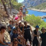
- Small group size (max 15) keeps the hike feeling personal and easier to manage on tricky bits.
- Pastré Park nature loop: Aleppo pines, oaks, laurels, thyme, juniper, and the Marseille canal show up in the scenery.
- Goat neck viewpoint with a cross is the high point for a picnic and the classic panorama.
- Descent through the flaws includes exposed passages, then caves and vegetation shift as you drop down.
- Callelongue from above plus a finish toward Goudes makes the later part of the hike feel calmer.
Price and logistics: what you’re really paying for
At $40.72 per person for a 4 to 5 hour hike, you’re paying for more than a trail. You’re paying for a guided route that strings together viewpoints, natural areas, and the “how to get there without guessing” part—especially helpful in a place like Marseille where the terrain can turn from easy footpath to rocky problem fast.
A few value points that matter:
- Snacks are included, so you’re not rationing energy until the very end.
- Mobile ticket keeps things simple on arrival.
- Group discounts can make this feel like a bargain if you’re traveling with friends (check what applies when you book).
- The admission ticket for the main stop is free, so your money goes toward guiding and organization, not fees at the gate.
The one “watch this” item is that transport isn’t included. You’ll want to plan your own way to the start.
Other hiking tours in Marseille
Getting to the start: Luminy as your launch pad
The meeting point is at 184 Av. de Luminy, 13009 Marseille. The good news: it’s described as near public transportation, so you don’t need to wrestle with parking plans.
Why Luminy works well for a hike like this: it sets you up close to the Parc National des Calanques world, while still letting the walk feel like a journey across Marseille rather than just a single out-and-back trail. If you can, aim to arrive a few minutes early so you can settle, use the restroom if needed, and get your bearings before the first climb.
And yes, your phone will matter: you’ll use the mobile ticket, so charge up and keep the confirmation handy.
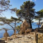
Stop 1: Parc National des Calanques and the view map in your head
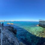
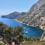
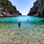
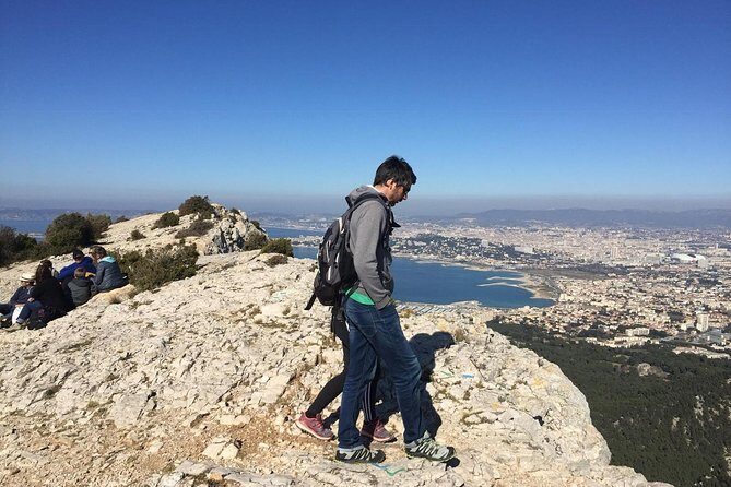
The hike begins with the core setting: Parc National des Calanques. You’ll get a panoramic look over Marseille and the bay, plus the Friuli archipelago and the island of Riou.
Here’s what I think is genuinely useful about this first viewpoint moment: it helps you understand where you are before you start moving. Once you’ve seen the bay and islands in the distance, the route makes more sense. You’re not just hiking—you’re gradually working toward higher angles and then later dropping into more sheltered terrain.
A quick practical tip: if the weather cooperates, this area is about visibility. Bring sunglasses and be ready for bright glare on open overlooks.
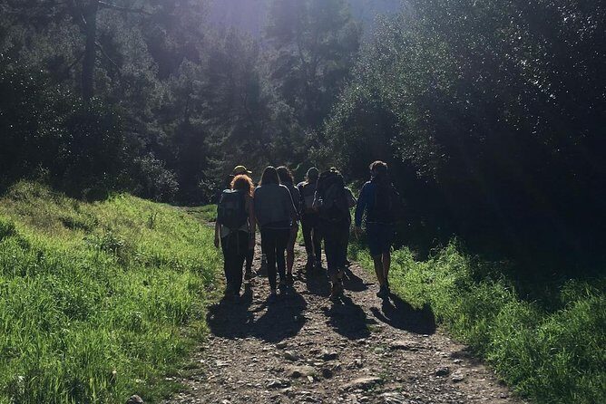
Pastré Park: where the hike starts to feel like nature, not just sightseeing
After the initial look, the route moves through Pastré Park, a natural area spread over several hectares. This is where the walk gets grounded in the place itself, not just the view.
You pass plant life that you can actually name and notice:
- Aleppo pines
- oaks
- laurels
- thyme
- a variety of juniper
- and you’ll also see the Marseille canal
Even if you don’t care about botany, this part changes your experience. Shade, scent, and the shift in ground texture make the hike feel longer in the best way—because you’re paying attention to details rather than just counting minutes.
This is also a good moment to reset your pace. The climb to the high point is coming, but Pastré Park helps you find rhythm.
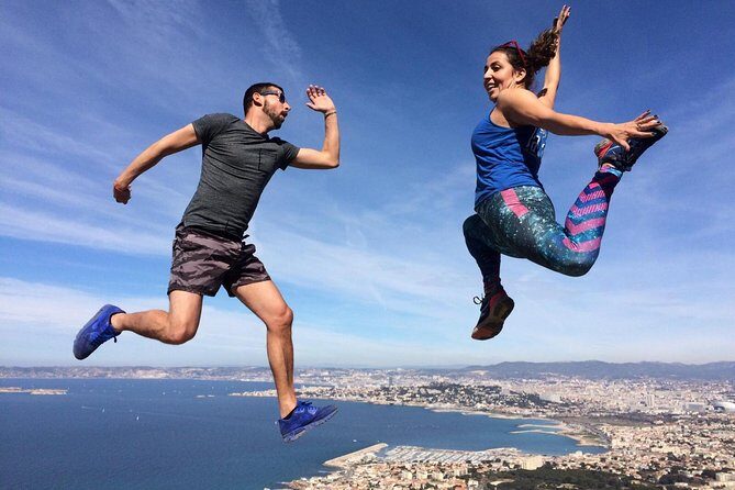
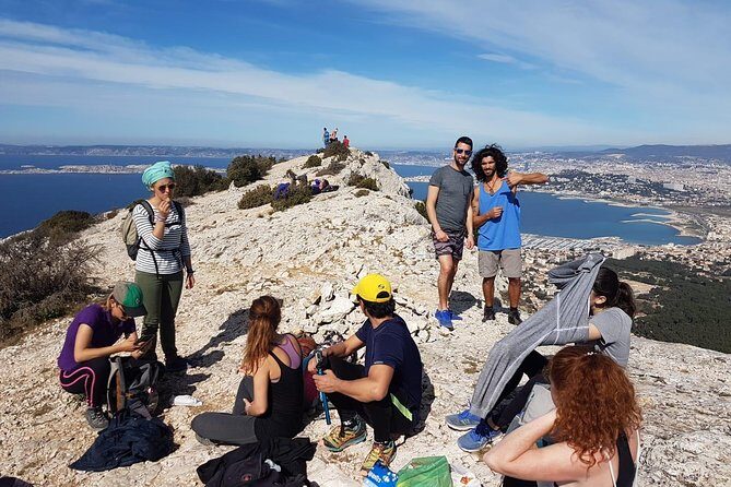
The goat neck cross: the high point (and the picnic that makes sense)
The big climb takes you up through the park to the goat neck at the top of the cross. Nothing here is described as very difficult, but you should expect a little hands-on movement: you may need to use your hands for balance.
Then comes one of the most satisfying parts of the day: picnic time paired with the panorama.
If you’ve ever been on a hike where the view is great but the timing is rushed, you’ll likely appreciate this setup. You reach the high point, you pause long enough to eat, and you can really take in the city-and-sea scale. The “picnic on top” format turns the climb into a payoff, not a chore.
Humor aside: you’ll feel like you earned your sandwich. Just don’t pack something that turns into a mess in warm wind.


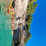
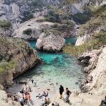
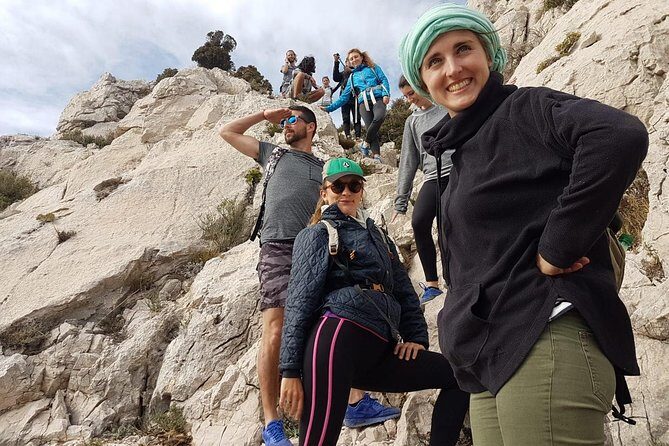
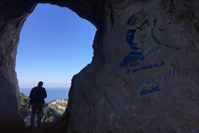
Descent through the flaws: where vigilance matters
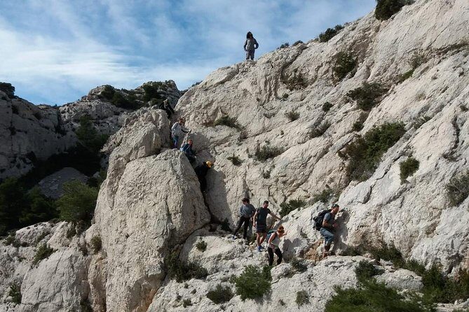
After the picnic and panorama, the route starts down through the flaws. This is where the trail asks more attention than strength.
The description calls out some exposed passages early in the descent. Translation: if you’re uneasy on rocky edges or with uneven footing, slow down and follow your guide’s cues. Your goal isn’t speed; it’s control.
After a few minutes, the scenery starts changing:
- you’ll come across caves
- vegetation begins to change as you descend
- the whole feel becomes more protected and textured
This “up high, then change” pattern is one of the reasons this hike feels richer than a simple viewpoint walk. You’re not just walking in one mood.
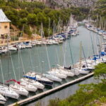
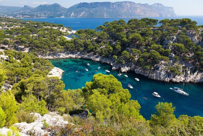
Callelongue from above: the view that earns the long way
As you continue the descent, you head toward Callelongue, which you’ll appreciate from above. This is a classic hiking reward: you see a different angle of the coast, then you know what you’re moving toward.
Callelongue from a height changes how you read the shoreline. You get a better sense of the arrangement of water, slopes, and paths—useful if you want to explore afterward on your own.
If you’re the type who likes to photograph, this segment is often the sweet spot: you’ve already done the hard part, but you’re still high enough for dramatic framing.
Finishing toward Goudes: relaxation after the rocky section
Once you reach the Callelongue area, the route shifts into a calmer rhythm. You’ll then walk to Goudes to relax.
This “later-stage ease” matters. A good panoramic hike shouldn’t only feel like work. Ending toward Goudes gives you a chance to:
- catch your breath after exposed sections
- enjoy the coastline at a slower tempo
- let the day shift from effort to enjoyment
And because the hike ends back at the meeting point, you’re not dealing with extra logistics that can steal your energy.
How fit do you need to be? Moderate, with real-world footing
The tour is aimed at people with a moderate physical fitness level. That sounds friendly, but the real question is terrain.
Expect:
- a climb up to the cross area
- a short segment where you may use your hands
- later descent with exposed passages that require vigilance
So yes, it’s not an extreme technical hike. But it’s also not a flat nature walk. If you have any hesitation with heights, slippery rocks, or uneven footing, take your time and choose footwear you trust.
A practical approach: think of this as a “good shoes” hike, not a “cute sneakers” hike.
Group size and guiding style: why the rating stays high
This experience caps at 15 travelers, which is a huge deal for a rocky coastal hike. In a small group, you get:
- clearer pacing
- more attention on balance issues
- less waiting around when the route tightens up
One theme in the positive feedback is the quality of the guide—patients, supportive, and genuinely good at helping people move through the trail. When a route has hand-use moments and exposed spots, the guide’s calm matters as much as the scenery.
If you’re the kind of person who wants to understand what you’re seeing while still moving, this style fits. The tour also has a specific eco-tourism mission, focused on proximity, local consumption, well-being, preservation of cultural heritage, and sustainable development. That isn’t just marketing language here—it shows up in how the hike is framed: you’re walking through the park and talking about its natural and local symbols, not racing past everything.
And that eco angle includes thoughtful behavior on the ground—strategies to minimize ecological footprint.
What’s included: snacks, not a full meal plan
You’ll get snacks included, which is helpful for keeping your energy stable around the picnic and viewpoint breaks.
What you should plan on your own:
- water (not stated as included)
- any extra food you want beyond the included snacks
- a small layer, since coastal weather can shift quickly
Bring what makes you comfortable on a 4–5 hour hike. It’s a guided day, but you’re still the one carrying your basics.
Photo permission and social media: a quick consent question
There’s an authorization question about publishing photos where you appear and participate in order to promote sustainable tourism on social media.
So if you prefer not to be featured online, plan your decision ahead of time. It’s a simple checkbox-type moment, but it’s worth thinking about before the day starts.
Weather: the one variable you can’t control
This hike requires good weather. If conditions aren’t right, you’re offered a different date or a full refund.
In places like the Calanques, “good weather” usually means you’ll have safer footing and better visibility for panoramas. If the forecast looks questionable, don’t stubbornly assume it’ll clear up. Let the operator’s weather judgment do its job.
Who should book this Marseille panoramic hike
Book it if you want:
- big coastal views over the bay and islands
- a guided route that connects nature and Marseille symbols
- a small group experience with a guide who helps you through tougher spots
- an outdoor day that’s active, but not a training plan
Skip it if you:
- strongly dislike heights or exposed rocky sections
- want only flat walking
- can’t handle occasional hand-on-rock balance moves
This tour is a great fit for couples, solo travelers who like companionship in small groups, and active visitors who want a “Marseille feel” beyond the postcard center.
Should you book Planetazur’s Calanques panorama hike?
Yes—if you’re comfortable with moderate hiking and you’re open to a few exposed moments where you must watch your footing. The price feels fair for a guided route with snacks, a small group cap, and a high point that’s built around a real picnic view.
If you’re chasing scenery, this delivers: the bay of Marseille, the islands (including Riou), and the look down toward Callelongue and onward to Goudes give you multiple angles in one day. And if you value guidance, the tour’s reputation for a patient, solid guide is a strong sign that the route won’t feel like you’re left to figure it out alone.
FAQ
FAQ
How long is the hike?
The duration is about 4 to 5 hours.
What’s the price per person?
It costs $40.72 per person.
Where do we meet and where does the tour end?
You meet at 184 Av. de Luminy, 13009 Marseille, France, and the hike ends back at the same meeting point.
Is admission included for Parc National des Calanques?
Admission at Parc National des Calanques is free.
What’s included in the tour?
Snacks are included.
Is transportation included?
No, private transportation is not included.
What happens if the weather is poor?
The experience requires good weather. If it’s canceled due to poor weather, you’ll be offered a different date or a full refund.
Is there a cancellation option if plans change?
Yes. You can cancel for a full refund up to 24 hours before the experience starts.